Burhans began cold-calling dioceses, offering to map all the properties they owned. Most dioceses she contacted— if they agreed at all— had their property records stored in a dusty box in a basement somewhere, so getting them all in order was a lot of work.
GoodLands’ work in this regard was groundbreaking— surprisingly so. Burhans quickly found that even seemingly simple online maps simply weren’t available, such as a map showing the precise boundaries of each diocese and the diocese’ name.
Burhans had sought out the advice of CARA, a Catholic research group based at Georgetown University in Washington D.C., to see if perhaps they had a digital map of all the U.S. dioceses. All they could offer her, she says, was a PDF that showed all the dioceses of the United States. Nothing interactive, and nothing global.
“There was no global map of anything except for this one on Wikipedia...it was made in Photoshop, pretty much, by a kid who was 16 and had pretty much painted it on. So that was the only global map of the church,” she said, adding that she later hired that “kid” as a paid intern.
By this point, Burhans had assembled a team of cartographers ready to create these maps that she sought. But still, she had her doubts. Surely the Vatican already had a mapping project like this, and maybe they had a good reason not to make the maps public. She didn’t want to reinvent the wheel, or worse, step on Pope Francis’ toes.
(Story continues below)
“I didn't want to go ahead with this project first, if the Vatican had it internally; second, if the Vatican had it internally and had good reason that I might not know for not releasing it publicly,” she said.
Turns out, she says...the Vatican didn’t have it. Burhans would have to make the maps herself— and she did.
Why maps?
Today, several years on, along with a team of nearly 3,000 cartographers, Burhans and GoodLands have managed to map almost every single piece of Church-owned property in the United States.
They haven’t made that particular map publicly available, but many of their other maps, containing a wealth of data, are available to view and download on the GoodLands website.
The beauty of mapping out everything the Church owns, Burhans says, is that it allows for better-informed decisions about what to do with the Church’s vast land holdings. It allows the Church’s leaders to better use what they have to further the Church’s mission, she says.
Many dioceses across the country are finding themselves with little choice but to sell off their buildings or land, as their coffers begin to run dry amid declining donations, church attendance, and increasingly, abuse lawsuits.
The data that GoodLands has collected is useful for much more than selling property, however. They’ve gathered a lot of information related to environmental concerns— properties at risk of flooding due to climate change, sea level rises, fire risk, etc.
There’s also a three-dimensional map of Boston with all the buildings and topography included throughout the diocese, mapped with NOAA-based data about sea level rise. They’ve also mapped properties most at risk for earthquakes in Los Angeles.
What’s next?
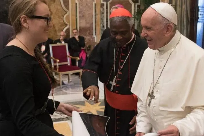
Burhans met with Pope Francis in 2018, and showed him one of her maps that she had created showing the percentage of Catholics in each diocese of the world. The pope was intrigued; soon after the meeting, he invited her to create a new institute of the Vatican dedicated to map-making, on a six-month trial basis.
If created, this would likely be the first female-founded department at the Vatican. But, ultimately, Burhans turned down that initial offer because it didn’t include any funding. She’s currently working on a proposal for a cartography institute— which she envisions as a “sister institute” to the Vatican observatory— that will, ideally, receive funding from the Vatican.
Obviously, the COVID-19 pandemic has slowed down those plans. But it hasn’t stopped Burhans from garnering more than a half-dozen awards from various organizations, most recently the Sierra Club. Burhans said GoodLands isn’t accepting new clients at the moment, partly because they’ve been inundated with so many requests from dioceses and other Catholic organizations.
Burhans speaks passionately about her hopes that her maps will provoke change in the Church, but she also says she has yet to see her maps move people in the way she hoped. Could a fully-fledged cartography institute at the Vatican change that? It remains to be seen, but Burhans is ready and willing to give it a try.
“A map is worth a million words...This will transform the operations of the Catholic church. I have little doubt,” she said.
A version of this story appeared on Episode 115 of the CNA Newsroom podcast. Click here to listen to the episode.
Jonah McKeown is a staff writer and assistant podcast producer for Catholic News Agency. He holds a Master’s Degree from the University of Missouri School of Journalism and in the past has worked as a writer, as a producer for public radio, and as a videographer.